
HIKING TRAILS & MAPS for:
Scientific Natural Areas
of the st. croix National scenic riverway
scientific natural areas
OF THE ST. CROIX RIVERWAY

Four scientific natural areas exist along the St. Croix National Scenic Riverway. Although SNA’s do not have maintained trails or recreational facilities, they are a great place to hike, birdwatch, or do some plant exploration.
See the full list of rules for visiting an SNA.
DIFFICULTY LEVEL: EASY TO INTERMEDIATE
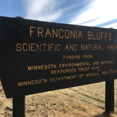
FRANCONIA BLUFFS SCIENTIFIC NATURAL AREA (SNA)
TRAIL USES:
SUMMER: HIKING
WINTER: HIKING, SNOWSHOEING, XC SKIING
Getting there:
Directions: From Taylors Falls 3.25 miles SW on US Hwy 8, then 1.25 miles S on MN Hwy 95. Park in pull-off on E.
Lat/Lon: 45.366905, -92.71241 – MAP IT
Directions: From Taylors Falls 3.25 miles SW on US Hwy 8, then 0.75 mile S on MN Hwy 95, then 370 feet E on drive. Park and hike E within signed corridor to bluffs. No parking along Franconia Trl.
Lat/Lon: 45.372498, -92.705362 – MAP IT
Although it has no river frontage, Franconia Bluffs is one of four SNAs along the St. Croix National Scenic Riverway between Taylors Falls and Scandia in what has been identified as a priority conservation area for the St. Croix Watershed. This site has no maintained trails or other recreational facilities. This site is an Audubon Important Bird Area. To learn more, visit the MN DNR website here.
TRAIL TYPE: FOOT TRAFFIC
TRAIL LEVEL: EASY TO INTERMEDIATE
SURFACE: NATURAL, NO MAINTAINED TRAILS
PASS REQUIRED: NO
LENGTH: 85 ACRES
NOTABLES: The rare Higgins eye mussel, listed as an endangered species at state and federal levels, has been documented in this stretch of the St. Croix.
DIFFICULTY LEVEL: EASY TO INTERMEDIATE
LAWRENCE CREEK SCIENTIFIC NATURAL AREA (SNA)
TRAIL USES:
SUMMER: HIKING
WINTER: HIKING, SNOWSHOEING, XC SKIING
Getting there:
Directions: From Taylors Falls 2.5 miles SW on US Hwy 8/St. Croix Trail, then 0.1 mile S on Unity Ave. Park in pull off at corner where Unity Ave turns W. Hike west through old field into woods of site. Restricted entry, see details above.
Lat/Lon: 45.379481, -92.687254 – MAP IT
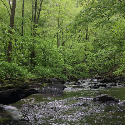
Just down river of Taylor’s Falls, this SNA protects an area of high biodiversity significance, with many rare and high quality natural features. It lies within a region known as the Franconia—St. Croix corridor, which displays nearly the full range of native plant communities found in the St. Croix National Scenic Riverway. To learn more, visit the MN DNR website here.
TRAIL TYPE: FOOT TRAFFIC
TRAIL LEVEL: EASY TO INTERMEDIATE
SURFACE: NATURAL, NO MAINTAINED TRAILS
PASS REQUIRED: NO
LENGTH: 72 ACRES
NOTABLES: The diversity of rare birds is extraordinary and include the Cerulean Warbler, Acadian Flycatcher, and Louisiana Waterthrush.
PHOTO © MN DNR, Kelly Randall
DIFFICULTY LEVEL: EASY TO INTERMEDIATE
FALLS CREEK SCIENTIFIC NATURAL AREA (SNA)
TRAIL USES:
SUMMER: HIKING
WINTER: HIKING, SNOWSHOEING, XC SKIING
Getting there:
Directions: From Copas 2.75 miles N on MN Hwy 95. Park in Wind-in-the-Pines Township lot on E near wood-routed sign.
Lat/Lon: 45.270982, -92.776293 – MAP IT
Directions: From Copas 3 miles N on MN Hwy 95. Park in lot on E near wood-routed sign.
Lat/Lon: 45.273334, -92.777916 – MAP IT
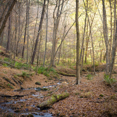
A Scandia city park called Wind in the Pines Preserve borders Falls Creek SNA on the southeast. Its trails provide a beautiful and easy access to the SNA (which does not have trails). Please note that the fishable areas of Falls Creek pass through private land, and neither Falls Creek SNA nor Wind in the Pines Preserve currently offer public access to the St. Croix River.
The work of water and time is expressed in dramatic terrain at Falls Creek SNA. Streams carve a winding path through steep-sided ravines as they make their way to the St. Croix River. Slopes face in all directions, providing a range of growing conditions and setting the stage for biodiversity. To learn more, visit the MN DNR website here.
TRAIL TYPE: FOOT TRAFFIC
TRAIL LEVEL: EASY TO INTERMEDIATE
SURFACE: NATURAL, NO MAINTAINED TRAILS
PASS REQUIRED: NO
LENGTH: 136 ACRES
NOTABLES: For geology buffs, faulting of bedrock here offers an interesting window into the past.
PHOTO © Justin Meissen
DIFFICULTY LEVEL: EASY TO INTERMEDIATE
CRYSTAL SPRING SCIENTIFIC NATURAL AREA (SNA)
TRAIL USES:
SUMMER: HIKING
WINTER: HIKING, SNOWSHOEING, XC SKIING
Getting there:
Directions: From Scandia 1.6 miles E on MN 97 (Scandia Trail), then 0.8 mile N on MN 95 (St Croix Trail, then 0.3 mile E on 220th St, then 0.3 mile S on Quarry Ave. Park only on E road shoulder. Hike 0.15 mile S along marked corridor to site.
Lat/Lon: 45.263196, -92.768251 – MAP IT
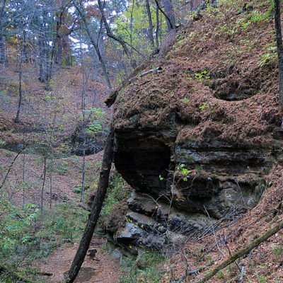
Made by water—an apt description of the pine-rimmed, rock-walled gorge that defines this site. For brief periods during the year, heavy rain and seasonal snowmelt enter from above, coursing through ravines and dropping over a sandstone ledge into the gorge. But the real action here is less about this fleeting waterfall than about what happens year-round at the foot of the ledge, where a perennial spring seeps from between layers of Jordan sandstone. To learn more, visit the MN DNR website here.
TRAIL TYPE: FOOT TRAFFIC
TRAIL LEVEL: EASY TO INTERMEDIATE
SURFACE: NATURAL, NO MAINTAINED TRAILS
PASS REQUIRED: NO
LENGTH: 38 ACRES
NOTABLES: Crystal Spring or Miniboha—this is a truly fragile site, where clambering on wet rock and slopes would quickly translate to loss of delicate mosses and water quality, the unraveling of ecological relationships long in the making. Enjoy gently.
PHOTO © MN DNR