HIKING

Hiking is a great way to enjoy the outdoors; it requires little more than the ability to pinpoint a good trail, lace up some sturdy shoes and you are off on an adventure.
Interstate Park WI
St. Croix Falls, WI
Interstate Park-WI
Trail Descriptions & MapsIce Age National Scenic Trail
St. Croix Falls & Gandy Dancer Segment
Ice Age National Scenic Trail
Trail Descriptions & MapsRegional WI Trails
Polk County, Osceola, & Dresser
Regional WI Trails
Trail Descriptions & MapsInterstate Park MN
Taylors Falls, MN
Interstate Park- MN
Trail Descriptions & MapsCity of Trails
St. Croix Falls
City of Trails
Trail Descriptions & MapsRegional MN Trails
Chisago Lakes, Wild River State Park, William O'Brien State Park, & St.Croix Riverway SNA's
Regional MN Trails
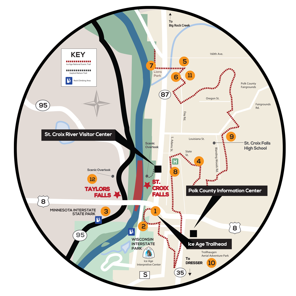
Trail Descriptions & MapsKey Trailheads
1. Interstate State Park – WI
Trailhead Address: 1275 State Highway 35 St. Croix Falls, WI 54024
2. ice age Trail – western terminus
Trailhead Address: 1275 State Highway 35, St. Croix Falls, WI 54024
3. interstate state park – mn
4. community fitness/Huff it trail
Trailhead Address: 740 Maple Drive, St. Croix Falls, WI
5. Wert family nature Preserve
Trailhead Address: 240th St, St. Croix Falls, Wisconsin 54024
6. Mindy creek trail
Trailhead Address: 689 N Day Rd, St Croix Falls, WI 54024
7. Indianhead Flowage trail
Trailhead Address: 809 N Hamilton St, St Croix Falls, WI 54024
8. hospital Esker Trail
Trailhead Address: Corner of Georgia & Vincent St., St Croix Falls, WI 54024
9. Reigel park trail
Trailhead Address: Fairgrounds Road, St Croix Falls, WI 54024
10. Stower seven lakes state trail
Trailhead Address: Lotus Lake County Park, 2142 90th Ave – Osceola, WI 54020
11. zillmer trail
Trailhead Address: 689 N Day Rd, St Croix Falls, WI 54024