
HIKING TRAILS & MAPS OF
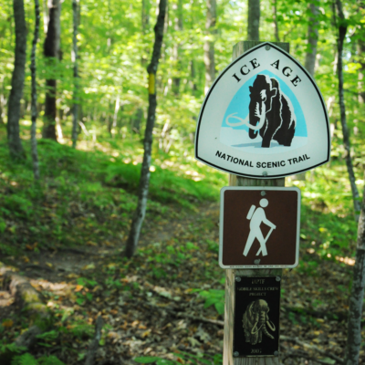
Ice Age National Scenic Trails
st. croix falls & gandy dancer segments
ICE AGE TRAILS

The Ice Age National Scenic Trail begins in St. Croix Falls, WI and traverses the entire state of WI stretching 1200 miles. Hike through these official Ice Age Trail segments, or tackle them as individual hikes.
Find your favorite trail!
ICE AGE TRAIL ALLIANCE:
INDIANHEAD CHAPTER
Dean Dversdall, Volunteer Chapter Coordinator
2670 103rd St.
Frederic, WI 54837
Phone: 715-205-4487
Email: edgelong@lakeland.ws

St. Croix Falls, WI is proud to be an official Ice Age Trail Community!
A WI State Park Pass is required for all trails within state parks.WI Residents: $28 annual/$8 daily fee. Non Residents: $38 annual/$11 daily fee. (2020 rates. Subject to change per the WI-DNR. For a full list of rates, go here.)
Visit the Ice Age Trail Alliance website for more information.
ST. CROIX FALLS SEGMENT
The St. Croix Segment is the western start point of the 1,200 mile trail that traverses all the way through the state of Wisconsin. The hike-through trail segment is 9 miles in length. To get to the next segment, the Gandy Dancer Segment, there is a 4.5 mile connecting route. You can hike the Ice Age as a through-hike, or take the hikes segment by segment. Below, please find information on the individual Ice Age Trails that are found in the St. Croix Falls area, as well as some of the connecting, pass-through, or spur trails.
DIFFICULTY LEVEL: INTERMEDIATE
POTHOLE TRAIL
TRAIL USES:
SUMMER: HIKING
WINTER: HIKING
WI Interstate State Park address:
1275 State Highway 35
St. Croix Falls, WI 54024
715-483-3747
MAP IT
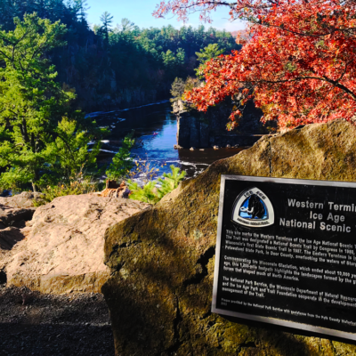
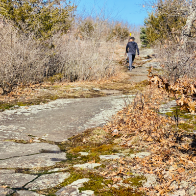
The western terminus of the 1,200 mile National Scenic Ice Age Trail starts right at the Pothole Trail inside Interstate Park, WI. The Pothole Trail is the most geologically unique trail in the park and is just a short hike to scenic views of the Dalles of the St. Croix River gorge. Walk atop Old Man of the Dalles rock formation and past world-famous potholes formed by glacial meltwaters.
TRAIL TYPE: FOOT TRAFFIC
TRAIL LEVEL: INTERMEDIATE
SURFACE: GRAVEL SURFACED, STONE STAIRS, UNEVEN TERRAIN
PASS REQUIRED: YES
LENGTH: .4 MILE LINEAR
NOTABLES: OBSERVATION DECK WITH BENCH, OFFICIAL ICE AGE SEGMENT TRAIL.
DIFFICULTY LEVEL: INTERMEDIATE
HORIZON ROCK TRAIL
TRAIL USES:
SUMMER: HIKING
WINTER: HIKING
WI Interstate State Park address:
1275 State Highway 35
St. Croix Falls, WI 54024
715-483-3747
MAP IT
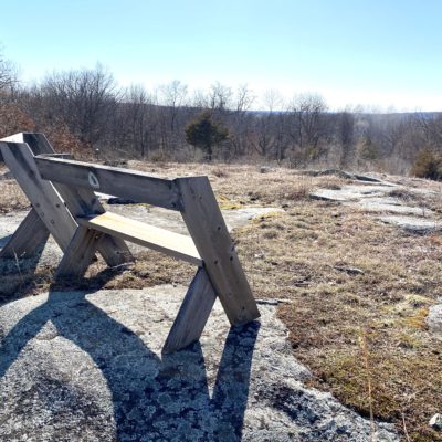
Route of the National Scenic Ice Age Trail, connects the Pothole Trail to the Ice Age Center. The trail ascends from cool damp creekbed up along a wooded bluff to high, dry Horizon Rock where prairie plants thrive. Named for it’s panoramic view of the river valley, Horizon Rock has a historic stone shelter from which to enjoy the view. Continue past the shelter to the Ice Age Center.
TRAIL TYPE: FOOT TRAFFIC
TRAIL LEVEL: INTERMEDIATE
SURFACE: HARD PACKED DIRT, NATURAL SURFACE, STONE STAIRS, UNEVEN TERRAIN
PASS REQUIRED: YES
LENGTH: .5 MILE LINEAR
NOTABLES: OBSERVATION POINT FROM SHELTER, OFFICIAL ICE AGE SEGMENT TRAIL.

DIFFICULTY LEVEL: EASY TO INTERMEDIATE
SKYLINE TRAIL
TRAIL USES:
SUMMER: HIKING
WINTER: HIKING & SNOWSHOEING
WI Interstate State Park address:
1275 State Highway 35
St. Croix Falls, WI 54024
715-483-3747
MAP IT
The longest trail in the park includes Skyline Nature Trail and part of the National Scenic Ice Age Trail. It connects the Pine Group Camp to the Ice Age Center and intersects Ravine Trail. The trail climbes past rock-strewn ravines to the forested rim of the valley.
TRAIL TYPE: FOOT TRAFFIC
TRAIL LEVEL: EASY TO INTERMEDIATE
SURFACE: HARD PACKED DIRT, NATURAL SURFACE, STONE STAIRS, UNEVEN TERRAIN
PASS REQUIRED: YES
LENGTH: 1.6 LINEAR MILE
NOTABLES: LONGEST TRAIL IN PARK, OFFICIAL ICE AGE SEGMENT TRAIL.

DIFFICULTY LEVEL: EASY
SKYLINE NATURE TRAIL
TRAIL USES:
SUMMER: HIKING
WINTER: HIKING & SNOWSHOEING
WI Interstate State Park address:
1275 State Highway 35
St. Croix Falls, WI 54024
715-483-3747
MAP IT
The self-guided interpretive trail begins at the Ice Age Center. Interpretive labels describe the changing landscape of plant communities.
TRAIL TYPE: FOOT TRAFFIC
TRAIL LEVEL: EASY. ACCESSIBLE.
SURFACE: NATURAL SURFACE
PASS REQUIRED: YES
LENGTH: .75 MILE LOOP
NOTABLES: INTERPRETIVE TRAIL, OFFICIAL ICE AGE SEGMENT TRAIL.
DIFFICULTY LEVEL: easy to intermediate
INTERLINK TRAIL
TRAIL USES:
SUMMER: HIKING, BIKING, INLINE SKATING
WINTER: HIKING
Trailhead address:
Polk County Information Center
710 Highway 35 S,
Saint Croix Falls, Wisconsin 54024
MAP IT
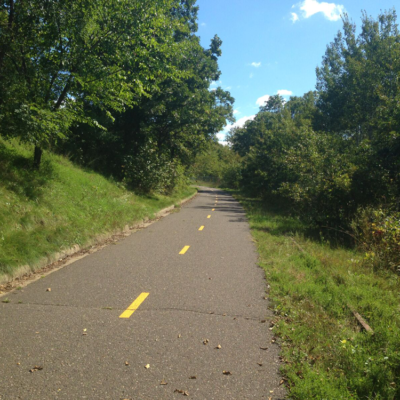
The Interlink Trail connects the southern end of the Gandy Dancer State Trail with Interstate Park in St. Croix Falls. The trailhead is located at the Polk County Tourism Center.
TRAIL TYPE: FOOT TRAFFIC, BIKE TRAFFIC
TRAIL LEVEL: EASY TO INTERMEDIATE, ACCESSIBLE, HILL CLIMB AND DESCENT.
SURFACE: PAVED
PASS REQUIRED: NO
LENGTH: 1.9 MILES
NOTABLES: YOU WILL NEED A BIKE PASS IF YOU CONTINUE ON TO THE GANDY DANCER STATE TRAIL. CONNECTING ROUTE FOR THE ICE AGE NATIONAL SCENIC TRAIL.
DIFFICULTY LEVEL: INTERMEDIATE TO advanced
hOSPITAL ESKER TRAIL
TRAIL USES:
SUMMER: HIKING
WINTER: HIKING
Trailhead address:
Corner of Georgia & Vincent St.
St Croix Falls, WI 54024
MAP IT
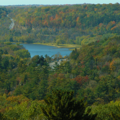
A glacial treasure lies in the heart of St. Croix Falls, Wisconsin. The Hospital Esker is one of the highest eskers in the state of Wisconsin. At almost 40 meters (~130 feet), it towers above the city below, creating a breathtaking view of the St. Croix River valley, the surrounding bluffs, and across the state border into Minnesota.
TRAIL TYPE: FOOT TRAFFIC
TRAIL LEVEL: INTERMEDIATE TO ADVANCED
SURFACE: NATURAL SURFACE, STEEP HILL
PASS REQUIRED: NO
LENGTH: .4 MILE LINEAR
NOTABLES: THE HILL ASCENT AT THE START OF THE TRAIL CLIMBS TO 130 FEET, OFFICIAL ICE AGE SEGMENT TRAIL.

DIFFICULTY LEVEL:INTERMEDIATE
COMMUNITY FITNESS TRAIL (HUFF-IT TRAIL)
TRAIL USES:
SUMMER: HIKING
WINTER: HIKING
Trailhead Address:
740 Maple Drive,
St. Croix Falls, WI
MAP IT
Crushed traprock trail through the woods. Multiple inclines and declines. Trail starts to the right of the sign. The packed dirt trail to the left of the sign is the Woolly MTB trail.
TRAIL TYPE: FOOT TRAFFIC
TRAIL LEVEL: INTERMEDIATE
SURFACE: CRUSHED TRAP ROCK
PASS REQUIRED: NO
LENGTH: 1.2 MILES LOOP
NOTABLES: SPUR TRAIL FOR THE ICE AGE NATIONAL SCENIC TRAIL.
DIFFICULTY LEVEL:INTERMEDIATE
REIGEL PARK TRAIL
TRAIL USES:
SUMMER: HIKING
WINTER: HIKING
Trailhead Address:
Fairgrounds Road,
St. Croix Falls, WI
MAP IT
The Florence Reigel Memorial Park is home to 76 acre park preserve is home to trails of rock ledges and trap rock meadows. Trailhead parking available on Blanding Woods Drive near Jerusalem Pond (follow paved Interlink trail east into woods, then take a left), or off Fairgrounds Road near the St. Croix Falls Dog Park.
TRAIL TYPE: FOOT TRAFFIC
TRAIL LEVEL: INTERMEDIATE
SURFACE: NATURAL, ROCK, BOULDER STAIRS, BOARDWALK
PASS REQUIRED: NO
LENGTH: .6 MILE LINEAR
NOTABLES: YELLOW BLAZES MARK THE ICE AGE TRAIL PATH, OFFICIAL ICE AGE SEGMENT TRAIL.
DIFFICULTY LEVEL:EASY TO INTERMEDIATE
ZILLMER TRAIL
TRAIL USES:
SUMMER: HIKING
WINTER: hIKING, SNOWSHOEING
Trailhead Address:
689 N Day Rd,
St Croix Falls, WI 54024
MAP IT
Trail winds through woods, meadows, and over streams. Hike straight through, or take the Zillmer Loop spur trail marked by white blazes.
TRAIL TYPE: FOOT TRAFFIC,
TRAIL LEVEL: EASY TO INTERMEDIATE
SURFACE: NATURAL SURFACE, DIRT, BOULDERS BOARDWALK, GRASS
PASS REQUIRED: NO
LENGTH: 1 MILE LINEAR
NOTABLES: OFFICIAL ICE AGE SEGMENT TRAIL.
DIFFICULTY LEVEL: intermediate
MINDY CREEK
TRAIL USES:
SUMMER: HIKING
WINTER: HIKING
Trailhead Address:
689 N Day Rd,
St Croix Falls, WI 54024
MAP IT
The trail entrance from Day Road will start you with a 26 foot long footbridge and lead you down to a boulder-strewn creek bed.The trail climbs back to the bluff’s edge where a meadow vista gives a open view before it tucks back into the woods and follows an old logging road toward WI-87.
TRAIL TYPE: FOOT TRAFFIC
TRAIL LEVEL: INTERMEDIATE
SURFACE: NATURAL, ROCK, DIRT, CREEK BED
PASS REQUIRED: NO
LENGTH: 1 MILE LINEAR
NOTABLES: STEEP BOULDER RAVINE, BLUFF VISTA, OFFICIAL ICE AGE SEGMENT TRAIL.
DIFFICULTY LEVEL: EASY TO INTERMEDIATE
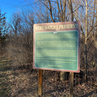
WERT PRESERVE
TRAIL USES:
SUMMER: HIKING
WINTER: HIKING, SNOWSHOEING, FAT BIKES AND XC SKIING ALLOWED, BUT NOT GROOMED.
Trailhead Address:
HWY 87/240th St
St. Croix Falls, Wisconsin 54024
MAP IT
Within the City of Trails lies 450 acres of protected woodland. Offering ski trails, hiking trails, and wildlife viewing/sanctuary. This land was preserved by the community of Saint Croix Falls, the Wert family, the West Wisconsin Land Trust, the Conservation Fund, the Ice Age Trail Foundation, and the Warren Knowles-Gaylord Nelson Stewardship Fund. Located across the highway from the St. Croix Falls Lions Park.
TRAIL TYPE: FOOT TRAFFIC
TRAIL LEVEL: EASY TO INTERMEDIATE
SURFACE: NATURAL, VARIED
PASS REQUIRED: NO
LENGTH: 450 ACRES
NOTABLES: TRAIL OF MYTHS IS A SPUR TRAIL FOR THE ICE AGE NATIONAL SCENIC TRAIL THAT RUNS THROUGH THE WERT PRESERVE.
DIFFICULTY LEVEL:EASY TO INTERMEDIATE
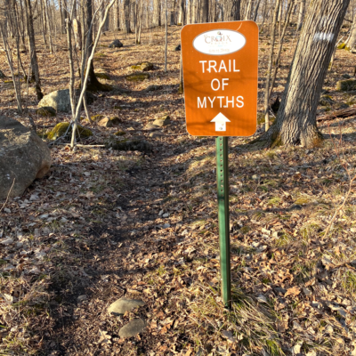
TRAIL OF MYTHS
TRAIL USES:
SUMMER: HIKING
WINTER: HIKING, SNOWSHOEING
Trailhead Address:
HWY 87/240th St
St. Croix Falls, Wisconsin 54024
MAP IT
Wooded trail through the woods over natural surface. Trail is lies within the Wert Preserve, which is 450 acres of protected woodland within the City of St. Croix Falls. Located across the highway from St. Croix Falls Lions Park.
TRAIL TYPE: FOOT TRAFFIC
TRAIL LEVEL: EASY TO INTERMEDIATE
SURFACE: NATURAL, PACKED DIRT
PASS REQUIRED: NO
LENGTH: 1.9 LINEAR
NOTABLES: SPUR TRAIL FOR THE ICE AGE NATIONAL SCENIC TRAIL.

DIFFICULTY LEVEL:easy
INDIANHEAD FLOWAGE TRAIL
TRAIL USES:
SUMMER: HIKING
WINTER: hIKING, SNOWSHOEING
Trailhead Address:
809 N Hamilton St,
St Croix Falls, WI 54024
MAP IT
The trailhead for this park is located at Lions Park in St. Croix Falls. This trail is mostly level, family friendly and crosses over several bridged streams as it tranverses through the woods. It runs north along the St. Croix River and opens up to an access point along the river. Trail becomes narrow and rustic toward the end as it terminates at River Road.
TRAIL TYPE: FOOT TRAFFIC
TRAIL LEVEL: EASY
SURFACE: FLAT, PACKED DIRT, NATURAL SURFACE
PASS REQUIRED: NO
LENGTH: 1 MILE LINEAR
NOTABLES: CURVES NORTH ALONG THE ST. CROIX RIVER. OFFICIAL ICE AGE SEGMENT TRAIL.
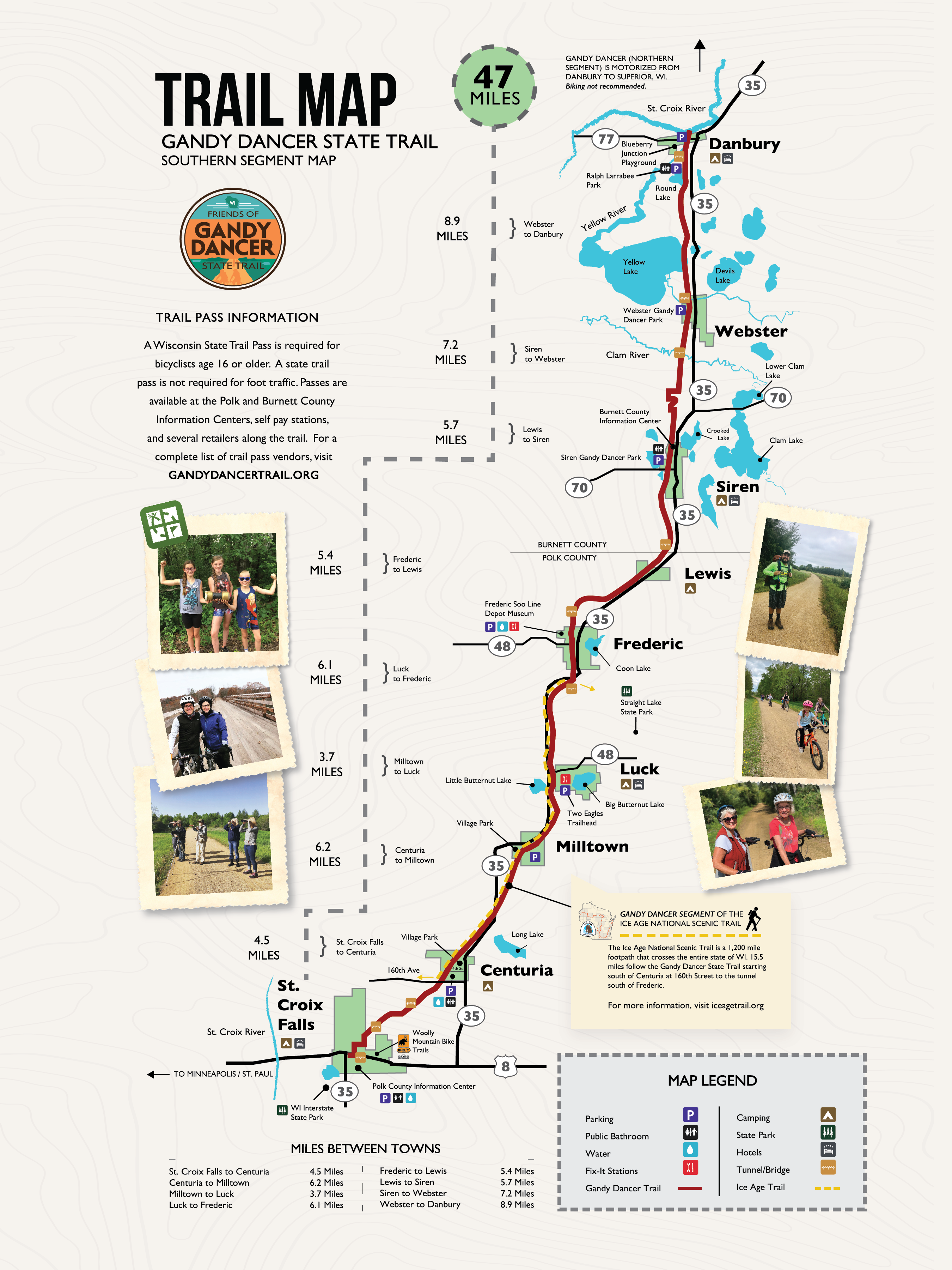
GANDY DANCER SEGMENT
The Gandy Dancer Segment of the Ice Age National Scenic Trail system officially starts in Centuria, WI off of 160th Avenue and is 15.5 miles in length. You can park at the Gandy Dancer State Trail parking area at the corner of Polk Avenue and 4th Street.
If you are hiking through from the St. Croix Falls Segment, follow the 4.5 mile connecting route from River Road. (Upon leaving the St. Croix Falls segment, turn right on River Road, then turn south on WI-87. Take a left on 160th Avenue until you reach the Gandy Dancer Segment. The start of the segment is where the Gandy Dancer State Trail crosses at 160th Avenue between 200th Street and Central Avenue. Follow the Gandy Dancer Segment for 15.5 miles until you reach the next segments: the Trade River Segment & the Straight Lake Segment.
Be sure to double back and do the section of the Gandy Dancer State Trail that passes through the beautiful City of St. Croix Falls!
DIFFICULTY LEVEL: easy
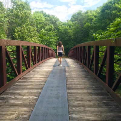
GANDY DANCER STATE TRAIL
TRAIL USES:
SUMMER: HIKING, BIKING
WINTER: FAT BIKING, HIKING, SNOWSHOEING, SNOWMOBILE AND FROZEN GROUND ATV/UTV USE.
Trailhead address in St. Croix Falls:
Polk County Information Center
710 Highway 35 S,
Saint Croix Falls, Wisconsin 54024
MAP IT
Trailhead address in Centuria:
Gandy Dancer State Trail Parking
Corner of Polk Ave and 4th Street
Centuria, Wisconsin 54824
MAP IT
The 98-mile recreation trail follows the railroad grade from St. Croix Falls north to Superior. Recreational use on the Trail is divided by geographic location: south half and north half. Enjoy a short stroll or a longer bike ride.
The south trail segment extends 47 miles from St. Croix Falls to Danbury, paralleling Hwy. 35 most of the distance. This segment was surfaced with crushed limestone in 1995 and offers a smooth, hard surfaced trail with use limited to biking and hiking from April through November. Spice up your adventure by stopping at the many small towns for a coffee or bite to eat along the way!
A State Trail pass is required of all bicyclists 16 years of age or older riding the Gandy Dancer Trail between St. Croix Falls and Danbury. Trail passes can be purchased at the Polk County Information Center, DNR stations, various local businesses and certain gas stations. Pass purchases are also available at self-pay stations along the trail, or by calling the DNR at 888-936-7463 between the hours of 7 am – 10 am. Pass fees are $25 annually/$5 daily. A Wisconsin Department of Natural Resources Conservation Patron license will be honored as a bike pass.
Visit the WI-DNR website for more trail information.
Distances
Mileage between southern towns along the Gandy Dancer Trail are as follows.
| St. Croix Falls to Centuria | 4.5 Miles |
| Centuria to Milltown | 6.2 Miles |
| Milltown to Luck | 3.7 Miles |
| Luck to Frederic | 6.1 Miles |
| Frederic to Lewis | 5.4 Miles |
| Lewis to Siren | 5.7 Miles |
| Siren to Webster | 6.6 Miles |
| Webster to Danbury | 8.9 Miles |
TRAIL TYPE: RAIL TO TRAIL
TRAIL LEVEL: EASY
SURFACE: FLAT, CRUSHED LIMESTONE
PASS REQUIRED: YES FOR BIKES
LENGTH: 98 MILES
NOTABLES: The official start of the Gandy Dancer Segment of the Ice Age National Scenic Trail starts in Centuria at 160th Avenue.
TRAILS OF INTERSTATE PARK WI
iNTERSTATE PARK – WI
Discover the full list of trails at Interstate Park – WI, home of the western terminus of the Ice Age National Scenic Trail.