
WISCONSIN INTERSTATE PARK

Interstate State Park, WI is a state park located along the St. Croix National Scenic Riverway. A total of 9 miles of summer trails and an additional 12.5 miles of winter trails are available to explore!
Find your favorite trail!
PARK ADDRESS:
1275 State Highway 35
St. Croix Falls, WI 54024
715-483-3747
MAP IT
A WI State Park Pass is required for all trails. WI Residents: $28 annual/$8 daily fee. Non Residents: $38 annual/$11 daily fee. Subject to change per the WI-DNR. For a full list of rates, go here.)
Visit the WI-DNR website or the FRIENDS OF WI INTERSTATE STATE PARK for more information.
DIFFICULTY LEVEL: INTERMEDIATE
HORIZON ROCK TRAIL
TRAIL USES:
SUMMER: HIKING
WINTER: HIKING
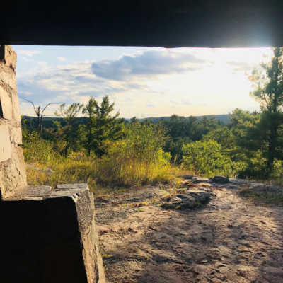
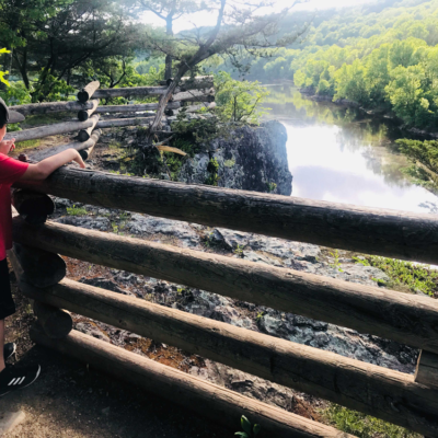
Route of the National Scenic Ice Age Trail, connects the Pothole Trail to the Ice Age Center. The trail ascends from cool damp creekbed up along a wooded bluff to high, dry Horizon Rock where prairie plants thrive. Named for it’s panoramic view of the river valley, Horizon Rock has a historic stone shelter from which to enjoy the view. Continue past the shelter to the Ice Age Center.
TRAIL TYPE: FOOT TRAFFIC
TRAIL LEVEL: INTERMEDIATE
SURFACE: HARD PACKED DIRT, NATURAL SURFACE, STONE STAIRS, UNEVEN TERRAIN
PASS REQUIRED: YES
LENGTH: .5 MILE LINEAR
NOTABLES: OBSERVATION POINT FROM SHELTER, OFFICIAL ICE AGE SEGMENT TRAIL.
DIFFICULTY LEVEL: INTERMEDIATE
POTHOLE TRAIL
TRAIL USES:
SUMMER: HIKING
WINTER: HIKING
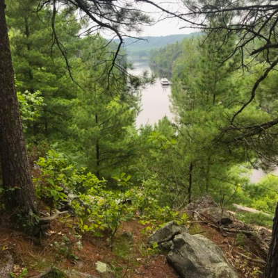
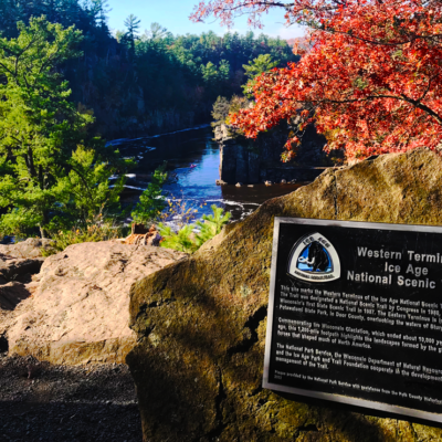
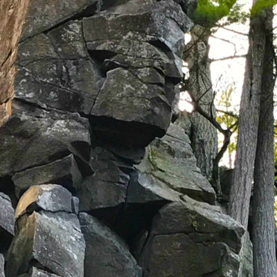
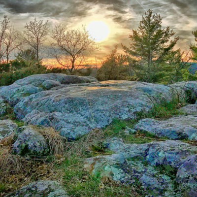
The western terminus of the 1,200 mile National Scenic Ice Age Trail starts right at the Pothole Trail inside Interstate Park, WI. The Pothole Trail is the most geologically unique trail in the park and is just a short hike to scenic views of the Dalles of the St. Croix River gorge. Walk atop Old Man of the Dalles rock formation and past world-famous potholes formed by glacial meltwaters.
TRAIL TYPE: FOOT TRAFFIC
TRAIL LEVEL: INTERMEDIATE
SURFACE: GRAVEL SURFACED, STONE STAIRS, UNEVEN TERRAIN
PASS REQUIRED: YES
LENGTH: .4 MILE LOOP
NOTABLES: OBSERVATION DECK WITH BENCH, OFFICIAL ICE AGE SEGMENT TRAIL.
DIFFICULTY LEVEL: INTERMEDIATE TO ADVANCED
MEADOW VALLEY TRAIL
TRAIL USES:
SUMMER: HIKING
WINTER: HIKING
Connects Horizon Rock Trail to the Beach parking area. Steep, switchback Talus Slope Trail descends the bluff below Horizon Rock Shelter to Meadow Valley Trail. Here the trail follows an extinct riverbed of glacial meltwaters now filled with ferns, mosses, and wildflowers.
TRAIL TYPE: FOOT TRAFFIC
TRAIL LEVEL: INTERMEDIATE TO ADVANCED
SURFACE: HARD PACKED DIRT, NATURAL SURFACE, STONE STAIRS, UNEVEN TERRAIN
PASS REQUIRED: YES
LENGTH: .3 MILE LINEAR
NOTABLES: SWITCHBACK TALUS SLOPE
DIFFICULTY LEVEL: INTERMEDIATE TO ADVANCED
SUMMIT ROCK TRAIL
TRAIL USES:
SUMMER: HIKING
WINTER: HIKING
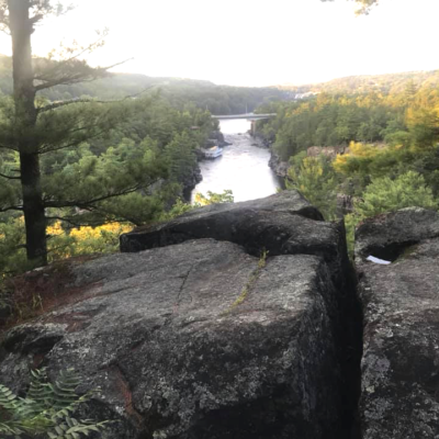
A trail to the highest point on the bluffs with spectacular views of the river gorge. At the intersection continue right through Canyon Valley to the Summit. View Old Man of the Dalles rock formation located high on the Wisconsin bluffs upriver from the Pothole Trail observation area. At the intersection past the Summit, stay left to return to the trailhead; to the right is Echo Canyon Trail.
TRAIL TYPE: FOOT TRAFFIC
TRAIL LEVEL: INTERMEDIATE TO ADVANCED
SURFACE: HARD PACKED DIRT, NATURAL SURFACE, STONE STAIRS, STEEP TERRAIN
PASS REQUIRED: YES
LENGTH: .5 MILE LOOP
NOTABLES: HIGHEST POINT ON THE BLUFFS
DIFFICULTY LEVEL: INTERMEDIATE TO ADVANCED
ECHO CANYON TRAIL
TRAIL USES:
SUMMER: HIKING
WINTER: HIKING
Connects Summit Rock Trail and Lake O’ the Dalles Trails. After leaving the Summit, the trail descends into Echo Canyon, and extinct riverbed carved by glacial meltwaters. The steep, rocky talus slope of the canyon walls cools the surrounding air. The trail intersects Lake O’ the Dalles Trail on the north shore.
TRAIL TYPE: FOOT TRAFFIC
TRAIL LEVEL: INTERMEDIATE TO ADVANCED
SURFACE: HARD PACKED DIRT, NATURAL SURFACE, STONE STAIRS, STEEP TERRAIN
PASS REQUIRED: YES
LENGTH: .5 LINEAR
NOTABLES: STEEP ROCKY SLOPE
DIFFICULTY LEVEL: INTERMEDIATE TO ADVANCED
RIVER BLUFF TRAIL
TRAIL USES:
SUMMER: HIKING
WINTER: HIKING
The trail intersects Lake O’ the Dalles Trail on the north shore. From the lake the trail winds between canyon and pond up to the precipitous edge of the lower gorge. Near its end, the trail descends 60 feet in elevation from bluff to River Bottoms Picnic Area.
TRAIL TYPE: FOOT TRAFFIC
TRAIL LEVEL: INTERMEDIATE TO ADVANCED
SURFACE: HARD PACKED DIRT, NATURAL SURFACE, STONE STAIRS, STEEP TERRAIN
PASS REQUIRED: YES
LENGTH: .4 MILE LINEAR
NOTABLES: STEEP ROCKY SLOPE
DIFFICULTY LEVEL: INTERMEDIATE
LAKE O' THE DALLES TRAIL
TRAIL USES:
SUMMER: HIKING
WINTER: HIKING
Wildlife viewing trail. Circles the 23 acre Lake O’ the Dalles, connects the Beach, River Bottoms, Picnic Area and Camp Interstate Shelter. Forty yards of the trail follows the park road where a bridge crosses Dalles Creek.
TRAIL TYPE: FOOT TRAFFIC
TRAIL LEVEL: INTERMEDIATE
SURFACE: HARD PACKED DIRT, NATURAL SURFACE, STONE STAIRS, UNEVEN TERRAIN
PASS REQUIRED: YES
LENGTH: 1 MILE LOOP
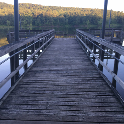
NOTABLES: ACCESSIBLE FISHING PIER, BEACH HOUSE, SWIMMING BEACH
DIFFICULTY LEVEL: INTERMEDIATE TO ADVANCED
eAGLE PEAK TRAIL
TRAIL USES:
SUMMER: HIKING
WINTER: HIKING
A trail to the highest point in the park overlooking the valley. Hike 120 feet in elevation from the Pines Group Camp up to Eagle Peak. Return from the Peak to the Group Camp or continue to the South Campground past a 1930’s CCC traprock quarry.
TRAIL TYPE: FOOT TRAFFIC
TRAIL LEVEL: INTERMEDIATE TO ADVANCED
SURFACE: HARD PACKED DIRT, NATURAL SURFACE, STONE STAIRS, UNEVEN AND STEEP TERRAIN
PASS REQUIRED: YES
LENGTH: .6 LINEAR MILE
NOTABLES: OBSERVATION POINT AND BENCH

DIFFICULTY LEVEL: EASY TO INTERMEDIATE
SKYLINE TRAIL
TRAIL USES:
SUMMER: HIKING
WINTER: HIKING & SNOWSHOEING
The longest trail in the park includes Skyline Nature Trail and part of the National Scenic Ice Age Trail. It connects the Pine Group Camp to the Ice Age Center and intersects Ravine Trail. The trail climbs past rock-strewn ravines to the forested rim of the valley.
TRAIL TYPE: FOOT TRAFFIC
TRAIL LEVEL: EASY TO INTERMEDIATE
SURFACE: HARD PACKED DIRT, NATURAL SURFACE, STONE STAIRS, UNEVEN TERRAIN
PASS REQUIRED: YES
LENGTH: 1.2 LINEAR MILE
NOTABLES: LONGEST TRAIL IN PARK, OFFICIAL ICE AGE SEGMENT TRAIL.
DIFFICULTY LEVEL: INTERMEDIATE TO ADVANCED
RAVINE TRAIL
TRAIL USES:
SUMMER: HIKING
WINTER: HIKING
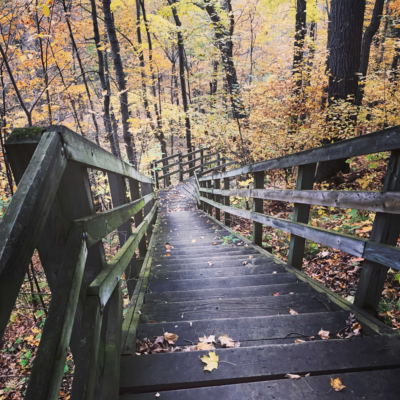
Connects Skyline Trail to the Beach parking area. The trail descends 260 feet in elevation from the rim of the valley through ferns and old growth forest to a stone shelter built in the 1930’s.
TRAIL TYPE: FOOT TRAFFIC
TRAIL LEVEL: INTERMEDIATE TO ADVANCED
SURFACE: HARD PACKED DIRT, NATURAL SURFACE, STONE STAIRS, UNEVEN TERRAIN
PASS REQUIRED: YES
LENGTH: .5 LINEAR MILE
NOTABLES: 40 WOODEN STEPS, SHELTER BUILDING
DIFFICULTY LEVEL: EASY
SILVERBROOK TRAIL
TRAIL USES:
SUMMER: HIKING
WINTER: MULTI-USE: HIKING, SNOWSHOEING, CROSS-COUNTRY SKIING (NON GROOMED)
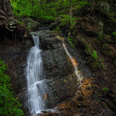
Wildlife viewing trail Hike through a variety of habitats to a remote area of the park rich in local history. The trail follows part of the original road from St. Croix Falls to Osceola. Pass by an abandoned copper mine to the grounds of Silverbrook Mansion and view the 18 foot Silverbrook Falls.
TRAIL TYPE: FOOT TRAFFIC
TRAIL LEVEL: EASY. ACCESSIBLE.
SURFACE: NATURAL SURFACE, MOSTLY FLAT, MOWED GRASS
PASS REQUIRED: YES
LENGTH: 1.2 LINEAR MILE
NOTABLES: ABANDONED COPPER MINE, 18 FOOT SILVERBROOK WATERFALL
PHOTO © BRAD NYGREN

DIFFICULTY LEVEL: EASY
SILVERBROOK TRAIL LOOP
TRAIL USES:
SUMMER: HIKING
WINTER: MULTI-USE: HIKING, SNOWSHOEING, CROSS-COUNTRY SKIING (NON GROOMED)
This 1.1-mile loop winds through forest and meadow to the southernmost part of the park. Take a short spur to view the 18-foot Silverbrook Falls.
TRAIL TYPE: FOOT TRAFFIC
TRAIL LEVEL: EASY. ACCESSIBLE.
SURFACE: NATURAL SURFACE, MOSTLY FLAT, MOWED GRASS, PACKED DIRT
PASS REQUIRED: YES
LENGTH: 1.1 LOOP
NOTABLES: 18 FOOT SILVERBROOK WATERFALL
DIFFICULTY LEVEL: EASY
SKYLINE NATURE TRAIL
TRAIL USES:
SUMMER: HIKING
WINTER: HIKING & SNOWSHOEING
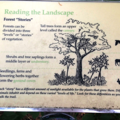
The self-guided interpretive trail begins at the Ice Age Center. Interpretive labels describe the changing landscape of plant communities.
TRAIL TYPE: FOOT TRAFFIC
TRAIL LEVEL: EASY. ACCESSIBLE.
SURFACE: NATURAL SURFACE
PASS REQUIRED: YES
LENGTH: .75 MILE LOOP
NOTABLES: INTERPRETIVE TRAIL, OFFICIAL ICE AGE SEGMENT TRAIL.
groomed ski trails & winter recreation trails
WINTER TRAILS
Interstate State Park in WI opens up additional recreation trails during the winter months for recreational sports such as cross country skiing and snowshoeing.
The winter trails are not maintained during summer and access to these trails is not available until the ground is frozen.
The Skyline Ski Trail is for skiers only. The 2.1 mile trail is groomed for classic cross-country skiing. The trail is open to skiers when the trail is snow-covered. Snowshoers, hikers, and pets are not allowed on the Skyline Ski Trail when the trail is snow-covered. The groomed Skyline Ski Trail begins at the Skyline Shelter.
Multi-use Winter Recreation Trails are open to snowshoeing, hiking, pets, and ungroomed cross-country skiing.
Additional Winter Trails
Skyline Ski Trail – 2.1 mi
Bluff Trail – 0.6 mi
Homestead Loop – 1.0 mi
Ojibwa Trail & Loop – 0.8 mi
Point Trail – 1.8 mi
Quarry Trail Loop – 2.0 mi