
june 3. 2023
National Trails Day!
5 Trails To Try
IN THE ST. CROIX VALLEY
We are known for our outdoor recreation and trails in this neck of the woods, and it’s awfully hard to pick just 5 trails to try. But, we pulled together this sampler list so you can get a feel for the variety of trails we have in this area. Whether you like to hike, bike, or run, we have a place for you.
Fun Facts:
- St. Croix Falls is known as the “City of Trails”.
- The western terminus of The 1,200 mile footpath called the Ice Age National Scenic Trail can be found inside Interstate State Park – WI on the Pothole Trail.
- Interstate Park is really two separate state parks: Interstate State Park – MN and Interstate State Park – WI. Each has their own campground, boat landings, trails and visitor centers.
- The Gandy Dancer Trail goes all the way north to Superior, WI! The southern segment is the best suited to hike or bike, while you’ll find more ATV use on the section north of Danbury, WI.

DIFFICULTY LEVEL: INTERMEDIATE TO ADVANCED
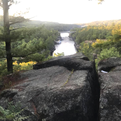
1. SUMMIT ROCK TRAIL (Interstate State Park - WI)
TRAIL USES:
SUMMER: HIKING
WINTER: HIKING
A trail to the highest point on the bluffs with spectacular views of the river gorge. At the intersection continue right through Canyon Valley to the Summit. View Old Man of the Dalles rock formation located high on the Wisconsin bluffs upriver from the Pothole Trail observation area. At the intersection past the Summit, stay left to return to the trailhead; to the right is Echo Canyon Trail.
TRAIL TYPE: FOOT TRAFFIC
TRAIL LEVEL: INTERMEDIATE TO ADVANCED
SURFACE: HARD PACKED DIRT, NATURAL SURFACE, STONE STAIRS, STEEP TERRAIN
PASS REQUIRED: YES
LENGTH: .5 MILE LOOP
NOTABLES: HIGHEST POINT ON THE BLUFFS
DIFFICULTY LEVEL: INTERMEDIATE
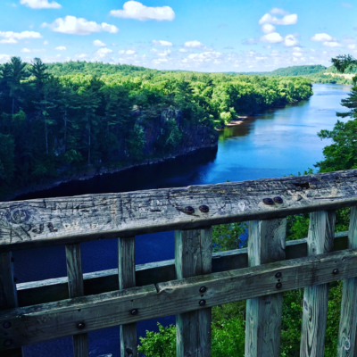
2. WALTER F. MONDALE RIVER TRAIL (Interstate State Park - MN)
TRAIL USES:
SUMMER: HIKING
WINTER: HIKING
Up and downhill trail with scenic overlooks of the St. Croix River. Watch for great blue herons, turkey vultures, and bald eagles.
TRAIL TYPE: FOOT TRAFFIC
TRAIL LEVEL: INTERMEDIATE
SURFACE: NATURAL AND GRAVEL SURFACE, STONE AND WOODEN STAIRS, UNEVEN TERRAIN
PASS REQUIRED: YES
LENGTH: 1.3 MILES LINEAR
NOTABLES: OBSERVATION DECK, RIVER VISTAS. CONNECT TO THE SANDSTONE BLUFFS TRAIL BY CROSSING HWY 8 VIA TUNNEL.
DIFFICULTY LEVEL: EASY
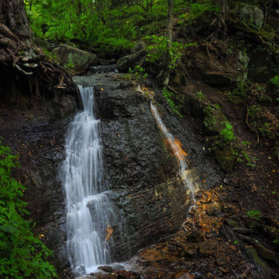
3. SILVERBROOK TRAIL (Interstate State Park - WI)
TRAIL USES:
SUMMER: HIKING
WINTER: MULTI-USE: HIKING, SNOWSHOEING, CROSS-COUNTRY SKIING (NON GROOMED)
Wildlife viewing trail Hike through a variety of habitats to a remote area of the park rich in local history. The trail follows part of the original road from St. Croix Falls to Osceola. Pass by an abandoned copper mine to the grounds of Silverbrook Mansion and view the 18 foot Silverbrook Falls.
TRAIL TYPE: FOOT TRAFFIC
TRAIL LEVEL: EASY. ACCESSIBLE.
SURFACE: NATURAL SURFACE, MOSTLY FLAT, MOWED GRASS
PASS REQUIRED: YES
LENGTH: 1.2 LINEAR MILE
NOTABLES: ABANDONED COPPER MINE, 18 FOOT SILVERBROOK WATERFALL
PHOTO © BRAD NYGREN
DIFFICULTY LEVEL: easy
4. GANDY DANCER STATE TRAIL
TRAIL USES:
SUMMER: HIKING, BIKING
WINTER: FAT BIKING, HIKING, SNOWSHOEING, SNOWMOBILE AND FROZEN GROUND ATV/UTV USE.
Trailhead address in St. Croix Falls:
Polk County Information Center
710 Highway 35 S,
Saint Croix Falls, Wisconsin 54024
MAP IT
Trailhead address in Centuria:
Gandy Dancer State Trail Parking
Corner of Polk Ave and 4th Street
Centuria, Wisconsin 54824
MAP IT
The 98-mile recreation trail follows the railroad grade from St. Croix Falls north to Superior. Recreational use on the Trail is divided by geographic location: south half and north half. Enjoy a short stroll or a longer bike ride.
The south trail segment extends 47 miles from St. Croix Falls to Danbury, paralleling Hwy. 35 most of the distance. This segment was surfaced with crushed limestone in 1995 and offers a smooth, hard surfaced trail with use limited to biking and hiking from April through November. Spice up your adventure by stopping at the many small towns for a coffee or bite to eat along the way!
A State Trail pass is required of all bicyclists 16 years of age or older riding the Gandy Dancer Trail between St. Croix Falls and Danbury. Trail passes can be purchased at the Polk County Information Center, DNR stations, various local businesses and certain gas stations. Pass purchases are also available at self-pay stations along the trail, or by calling the DNR at 888-936-7463 between the hours of 7 am – 10 am. Pass fees are $25 annually/$5 daily. A Wisconsin Department of Natural Resources Conservation Patron license will be honored as a bike pass.
Visit the WI-DNR website for more trail information.
Distances
Mileage between southern towns along the Gandy Dancer Trail are as follows.
| St. Croix Falls to Centuria | 4.5 Miles |
| Centuria to Milltown | 6.2 Miles |
| Milltown to Luck | 3.7 Miles |
| Luck to Frederic | 6.1 Miles |
| Frederic to Lewis | 5.4 Miles |
| Lewis to Siren | 5.7 Miles |
| Siren to Webster | 6.6 Miles |
| Webster to Danbury | 8.9 Miles |
TRAIL TYPE: RAIL TO TRAIL
TRAIL LEVEL: EASY
SURFACE: FLAT, CRUSHED LIMESTONE
PASS REQUIRED: YES FOR BIKES
LENGTH: 98 MILES
NOTABLES: The official start of the Gandy Dancer Segment of the Ice Age National Scenic Trail starts in Centuria at 160th Avenue.

DIFFICULTY LEVEL:easy
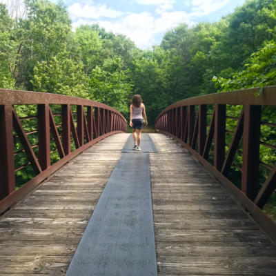
5. INDIANHEAD FLOWAGE TRAIL
TRAIL USES:
SUMMER: HIKING
WINTER: hIKING, SNOWSHOEING
Trailhead Address:
809 N Hamilton St,
St Croix Falls, WI 54024
MAP IT
The trailhead for this park is located at Lions Park in St. Croix Falls. This trail is mostly level, family friendly and crosses over several bridged streams as it tranverses through the woods. It runs north along the St. Croix River and opens up to an access point along the river. Trail becomes narrow and rustic toward the end as it terminates at River Road.
TRAIL TYPE: FOOT TRAFFIC
TRAIL LEVEL: EASY
SURFACE: FLAT, PACKED DIRT, NATURAL SURFACE
PASS REQUIRED: NO
LENGTH: 1.8 MILE LINEAR
NOTABLES: CURVES NORTH ALONG THE ST. CROIX RIVER. OFFICIAL ICE AGE SEGMENT TRAIL.
This article was written by Linda Shober and produced by Linda Shober Marketing + Design, a marketing firm located in the St. Croix Valley specializing in providing content, strategy, management, design, and creative for digital and traditional marketing projects.