
Scenes from the St. Croix
A HISTORICAL OVERVIEW OF THE ST. CROIX RIVER VALLEY
photo © kelly jorgenson
HISTORY

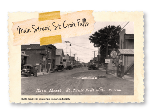
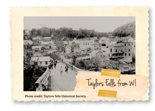
Taylors Falls, MN & St. Croix Falls, WI
Located on a unique stretch of river, the charming sister cities of St. Croix Falls, WI and Taylors Falls, MN sit just north of Osceola, WI and are the Gateway to the Upper St. Croix River Valley. This Valley carved hundreds and thousands of years ago by glaciers, is a popular vacation destination featuring parks, ample recreation, delicious dining, unique shopping, and convenient lodging.
The St. Croix River Valley and its surrounding area were originally occupied by the semi-nomadic American Indian Tribes. These people lived mainly on wild rice, fish and game. As the valley moved into the eighteenth century, two primary tribes inhabited the area, the Ojibwe and the Dakota. Eventually, the Dakota were driven out of the area after the Battle of Kathio.
In the 1830s, immigrants began to settle on both sides of the Upper St Croix River Valley. A lush history of French fur trade, interchange with the native people of the St. Croix, and western expansion led to a period in history that began the logging and immigration eras that forever changed the St. Croix River Valley. Taylors Falls and St. Croix Falls became the northernmost site navigable by steamboat attracting entrepreneurs of all kinds.
The Swedish, Danish, Norwegian, German and others came to this area, but because of Vilhelm Moberg’s writings, Chisago County is noted in Minnesota and remembered/celebrated in Sweden. Taylors Falls was the primary gateway for the earliest Swedish settlers coming on steamboats up the St. Croix River and the many thousands who followed, establishing settlements throughout Chisago County. The first four Swedish families to the Taylors Falls landing on April 23, 1851, were met by another Swede, Eric Nordberg, whose letters enticed them to come by steamboat from Moline, Illinois. The history of this first-party came alive in Vilhelm Moberg’s novels and the motion pictures “The Emigrants” and “The New Land.”
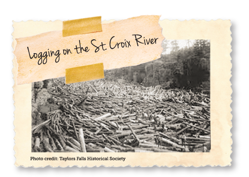
The famous log jam of 1886 intrigued reporters and photos of the colossal log piles were published all over the world. These piles reached into the Dalles and backed up for nearly seven miles north on the river. This region soon became threatened by the mining industry prompting community leaders from both the Minnesota and Wisconsin sides to take action to preserve this exquisite valley. These leaders worked together to establish the first interstate park in the nation consisting of approximately 1,600 acres.
In 1907 the river’s great power was harnessed by the creation of a hydroelectric dam. This dam supplied power to the Minneapolis and St. Paul metropolitan areas and served as the entry to the upper St. Croix River. It has been protected since 1968 under the Wild & Scenic Rivers Act.
In addition to all this production, historic buildings are found in both communities. A neighborhood reminiscent of a New England-style village, known as the Angel Hill District, is one of the attractions on the Taylors Falls side of the Valley. This district is home to the 1855 Folsom House (a Minnesota State Historic Site and stately home of a lumber baron), the 1861 United Methodist Church (the second oldest operating church in Minnesota), and the oldest schoolhouse in Minnesota built in 1852. The Baker Land & Title Building (Queen Anne Style) and the Auditorium are located on the St. Croix Falls side and are both on the National Register of Historic Places. These historic places are nestled amongst many historic commercial and residential buildings.
The geology of the Upper St. Croix Valley is unique in itself as it hosts claim to a scenic gorge, exposed cliff rocks remnant of ancient flood basalts, potholes, moraine deposits, and the Wellness Esker. Explorers of all ages are sure to enjoy the great St. Croix River Valley. Visit the itinerary page today to plan your adventure.
st. croix vallley trivia
FUN FACTS!
What is a Wannigan?
A Wannigan (from the Ojibwa word waanikaan) is a floating shack, similar to a houseboat. They were typically 25 to 30 feet in length, built low to the water for stability on swift-running rivers. The cabin was large enough to accommodate a cook, basic supplies and a sleeping area. Lumbermen used Wannigans on the St. Croix when it was still used as a logging route.
What is a Dalles?
The origin of the word Dalles comes from the French, plural of dalle gutter. It is simply the rapids in a river that run between the steep walls of a canyon or gorge.
Where are the Falls?
The falls were a string of pouring rapids that went upstream 4-5 miles starting at St. Croix Falls and Taylors Falls. When the hydroelectric dam was built in 1906, the falls came to an end.
What is a Pothole?
Potholes are deep circular holes in a riverbed. They are formed by the swirling of sand, gravel, and rock in a spinning whirlpool of water. The constant grinding of these materials creates the smooth round cavities.
What is an Esker?
Produced as a result of running water around a glacier, an esker is a long, winding ridge of stratified sand and gravel.
Our Story
Although the sister towns of Taylors Falls and St. Croix Falls are in different states, they share a common history and a scenic, natural beauty that spans from either side of the river that divides them. Picturesque villages with historic main streets dot the St. Croix River banks atop towering bluffs, only slightly breaking the lush forests and wild vegetation around them. To paddle the river or hike a nearby trail evokes a feeling of timelessness, as through traversing a path that has existed just so since the dawn of time. But nature and humans have lent a hand to continually evolve this landscape and shape it into what it is today.
photo © TAYLORS FALLS HISTORICAL SOCIETY
HISTORICAL TIMELINE
1.1 BILLION YEARS AGO
Geology sets the stage
Throughout history, the landscape of the St. Croix River valley has looked radically different. Around 1.1 billion years ago, the earth split along a rift that stretched from Lake Superior all the way down to Kansas, spewing forth lava that would eventually weather into dark, basalt rock. Fast forward to around 550 million years ago when shallow seas dominated the area, depositing sand and sediment which compacted into layers of sandstone on top of the basalt bedrock. Approximately 2.5 million years ago two separate glacial lobes converged, advancing and receding, and sculpting rock terraces in the process. When the last of the glaciers retreated 10,000 years ago, their meltwaters rushed through the valley forming the St. Croix River.
1.1 BILLION YEARS AGO
10,000 YEARS AGO
Early human inhabitants
Evidence suggests that humans have occupied the land surrounding the St. Croix River as early as 10,000 years ago. Artifacts such as spearheads, javelin points, tools, and animal kill sites have been unearthed in the region indicating that prehistoric human populations from the Paleo, Archaic, and Woodland cultures either passed through or inhabited the area. It is theorized that the nomadic and skilled Paleoindian hunters of the Ice Age may have contributed to the extinction of giant mastodons and woolly mammoths in North America.
The St. Croix River was used as a trade route between tribes for at least 9,000 years prior to the arrival of Europeans. Unearthed copper from the Lake Superior basin and red pipestone from northern Wisconsin were found in caves and
10,000 YEARS AGO
500+ YEARS AGO
The Dakota and Ojibwe
The first historical inhabitants of the St. Croix River Valley were the Dakota, largely considered to be part of the late Woodland cultural tradition. Their vast territory between the St. Croix and Mississippi rivers was rich in game, fish, and food plants that were spread across the area, causing a semi-nomadic lifestyle structured around seasonal food resources. The springtime was for processing maple sugar; summer brought the gathering of berries, nuts, roots, and wild greens, and later tending small gardens of corn, beans, and squash; late summer and early fall were spent near the banks of rivers and lakes for wild ricing; in the winter, they moved toward the woods for game hunting. Fishing outposts circled the basecamps in all seasons.
500+ YEARS AGO
LATE 1600S
Fur Traders Seek their Fortunes
In the late 1600s, French voyageurs began to explore the St. Croix River valley. Coming from the east in canoes, the voyageurs’ route flowed through the Great Lakes to the Bois Brule River to Lake Superior, where they portaged down to the headwaters of the St. Croix carrying enormous loads of supplies, befriending Ojibwe, and claiming territory along the way for New France.
LATE 1600S
LATE 1700S
Lumbermen Lured by White Pine Forests
As the fur trade entered its desperate final throes, bold entrepreneurs plotted to seek their fortunes in the fir trade. The St. Croix valley was rich in white pine situated conveniently on the banks of a river that could efficiently transport them to mill and market. The earliest loggers set up camp illegally on Ojibwe land. After the treaty of 1837, the land became government-owned and small crews operating with less than 20 men felled trees with axes during the cold winters, dragged them to the shoreline with oxen or manpower, and used the higher water level after the springtime snow melt to drive their harvest downstream.
LATE 1700S
EARLY 1800S
Farm Culture Grows
Farming grew up alongside logging. In the 1840s, all the land of the St. Croix valley was part of St. Croix County in the Wisconsin Territory. The first farmers to grab pieces of land provided food to logging camps or worked small sustenance farms. In 1848, Wisconsin became an official state of the union and the year after, the Minnesota Territory was formed. There was much dispute over Wisconsin’s eastern border, with many wishing to keep the St. Croix valley within one state, but eventually a boundary at the river was established, dividing the valley in two.
EARLY 1800S
LATE 1800S
Preservation Leads to Recreation
It didn’t take long for residents of St. Croix Falls and Taylors Falls to realize the bounty of natural beauty and scenic wonders right outside their front doors. In an effort to protect these treasures, citizens began to lobby to create a state park in the Dalles area and in 1895 Interstate Park was formed. Spanning both sides of the river and maintained by the Departments of Natural Resources in Wisconsin and Minnesota, it was the first park in the United States to be located in two states.
LATE 1800S
PRESENT DAY
A Tale of Two Cities: Taylors Falls & St. Croix Falls
Although ancient peoples had traipsed through the region for centuries, the first permanent settlers of Taylors Falls and St. Croix Falls came as loggers from the eastern part of the country. The waterpower provided by the mighty falls just upriver from the two towns were a huge draw and important to establishing the beginnings of the industry and the history of the communities.
PRESENT DAY
Geology sets the stage
1.1 BILLION YEARS AGO: Throughout history, the landscape of the St. Croix River valley has looked radically different. Around 1.1 billion years ago, the earth split along a rift that stretched from Lake Superior all the way down to Kansas, spewing forth lava that would eventually weather into dark, basalt rock.
Early human inhabitants
10,000 YEARS AGO: Evidence suggests that humans have occupied the land surrounding the St. Croix River as early as 10,000 years ago. Artifacts such as spearheads, javelin points, tools, and animal kill sites have been unearthed in the region indicating that prehistoric human populations...
The Dakota and Ojibwe
500+ YEARS AGO: The first historical inhabitants of the St. Croix River Valley were the Dakota, largely considered to be part of the late Woodland cultural tradition. Their vast territory between the St. Croix and Mississippi rivers was rich in game, fish, and food plants that were spread...
Fur Traders Seek their Fortunes
LATE 1600S: In the late 1600s, French voyageurs began to explore the St. Croix River valley. Coming from the east in canoes, the voyageurs’ route flowed through the Great Lakes to the Bois Brule River to Lake Superior, where they portaged down to the headwaters of the St. Croix...
Lumbermen Lured by White Pine Forests
LATE 1700S: As the fur trade entered its desperate final throes, bold entrepreneurs plotted to seek their fortunes in the fir trade. The St. Croix valley was rich in white pine situated conveniently on the banks of a river that could efficiently transport...
Farm Culture Grows
EARLY 1800S: Farming grew up alongside logging. In the 1840s, all the land of the St. Croix valley was part of St. Croix County in the Wisconsin Territory. The first farmers to grab pieces of land provided food to logging camps or worked small sustenance farms. In 1848, Wisconsin...
Preservation Leads to Recreation
LATE 1800S: It didn’t take long for residents of St. Croix Falls and Taylors Falls to realize the bounty of natural beauty and scenic wonders right outside their front doors. In an effort to protect these treasures, citizens began to lobby to create a state park in the Dalles area and in 1895...
A Tale of Two Cities
PRESENT DAY: Although ancient peoples had traipsed through the region for centuries, the first permanent settlers of Taylors Falls and St. Croix Falls came as loggers from the eastern part of the country. The waterpower provided by the mighty falls just upriver from the two towns were a...
SWIPE TO NAVIGATE
SWIPE TO NAVIGATE
SWIPE TO NAVIGATE
SWIPE TO NAVIGATE
SWIPE TO NAVIGATE
SWIPE TO NAVIGATE
SWIPE TO NAVIGATE
SWIPE TO NAVIGATE
What you can see today.
Create your own self-guided historical tour of the notable buildings, landmarks, points of interest, and natural resources that make up our beautiful St. Croix Valley.
Glacial Potholes at Interstate Park
Glacial meltwater sediment swirled with such great velocity as to drill holes in the hard basalt lining the St. Croix River. More than 100 potholes pock the landscape on both sides of the river, the deepest measuring in near 70 feet deep. It is the largest concentration of these formations in the United States and only one other site in the world in Switzerland rivals it.
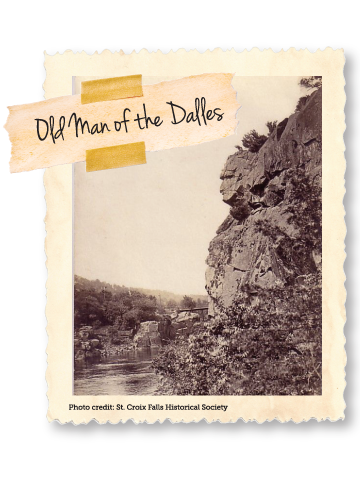
The Old Man of the Dalles
The Dalles of the St. Croix, where river rapids flow through a deep gorge cut into the ancient bedrock, is home to the Old Man of the Dalles, a natural rock formation standing sentinel over the river.
Eskers
These spine-like, winding ridges formed by retreating glaciers can be trod upon at Interstate Park trails.
Ice Age Interpretive Center
Learn more about glaciation in Wisconsin and Minnesota at the Ice Age Interpretive Center at Interstate Park. The center shows a short film, houses various displays, and provides information on how to best view the natural phenomena of the area.
Site of the Battle of the Dalles
Around 1770, the Dakota and Fox tribes engaged a massive force of Ojibwe at the Dalles of the St. Croix. The Ojibwe were near defeat when timely reinforcements arrived to turn the tide of battle. Both sides suffered heavy losses, but the Ojibwe emerged victorious, temporarily seizing control of the Upper St. Croix valley and setting an informal boundary near the mouth of the Snake River. The rocky shoreline and “boiling” rapids of the dalles at St. Croix Falls look much the same as they did at the time of this battle.
1825 Treaty Boundary
An 1825 treaty established a boundary between the Dakota to the south and the Ojibwe to the north at Cedar Bend where the St. Croix River elbows eastward, near the Washington-Chisago County boundary, just north of Falls Creek Scientific and Natural Area off MN-highway 95.
“St. Croix River” on Maps and Signs
The St. Croix River has had many monikers. Riviere Trombeaux (French for River of the Grave) was coined by Father Louis Hennepin in 1683, possibly referring to a Native American gravesite. Jean-Baptiste-Louis Franquelin’s 1688 map which sited Fort St. Croix at the mouth of the river and a grave marked with a cross belonging to a French voyageur, possibly a fur trader named Sainte-Croix, likely contributed to the more widespread use of Riviere de Sainte-Croix (French for Holy Cross). Ojibwe language names include Gichi-ziibi (Big River), Manoominikeshiinh-ziibi (Ricing-Rail River), Okijii-ziibi (Pipestem River), Jiibayaatig-ziibi (Grave-marker River – to commemorate the many battles between the warring Ojibwe and Dakota fought on the shores of the river). An 1830 map designates the St. Croix as the Chippewa River, but in 1843, Joseph Nicollet’s writings reinforced the name St. Croix, providing a lasting testimony of the French influence in the region.
Trading Posts
Although fur trading posts were once scattered along the St. Croix River and its tributaries, few remain today. Federal Indian Agents, tasked with keeping the peace between the feuding Dakota and Ojibwe, removed many of the posts near the tribal boundaries in an effort to keep the groups separated. An American trading post about four miles upstream of Taylors Falls was burned by Agent Henry Rowe Schoolcraft in 1832 because the Dakota and Ojibwe were “improperly brought into contact.” A 1753 French fur post was once located at the mouth of the Sunrise River on the grounds of what is now Wild River State Park. The Snake River Fur Post near Pine City, MN is a reconstruction of the British North West Company’s 1804 trading post. Now owned and operated by the Minnesota Historical Society, visitors can view exhibits, learn about the fur trade, and explore the grounds of the valley’s earliest global trade.
Angle Rock
The St. Croix River narrows considerably at the Dalles and the water quickens its pace. From the Minnesota shoreline, a large promontory juts into the channel, sharply changing the angle of the river. As logs careened between the sheer, confining trap rock walls of the Dalles, they were often unable to make the 90-degree turn at Angle Rock, causing backups for miles, halting all lumber production in the valley.
Nevers Dam
As log jams at Angle Rock increasingly vexed lumbermen, Frederick Weyerhaeuser undertook to eliminate them by constructing Nevers Dam. In 1889 he spent $250,000 to build the largest wood-piling structure in the world 11 miles upstream from the jam site. The 614-feet-wide dam featured an enormous bear-trap gate to control water flow, a holding pen with 15 sluice gates, and electric lights to allow for round-the-clock sluicing. Nevers Dam was removed in 1955, but the ice breaker islands and earth works are still visible at Nevers Dam Landing and Wild River State Park.
Original St. Croix Boomsite
Originally owned and operated by men of the Osceola, Taylors Falls, and Marine on St. Croix area, the boomsite was located near Osceola Landing before eventually moving to Stillwater to more effectively service the large flow of timber from tributaries further downstream.
The First Saw Mill in the Valley
In the spring of 1839 Lewis Judd and David Hone formed the Marine Lumber Company in Marine on St. Croix and built a fully operational mill by fall. The remains of this mill rest beside the mill stream, marked with interpretive signs, in the heart of historic Marine.
The St. Croix Falls Lumber Company
: Immediately following the treaty of 1837, the St. Croix Lumber Company began construction on a mill at the falls, but the inexperienced crew faced so many building challenges on the site that it was not completed until 1842. By that time, it was realized that the Dalles was not an ideal location for a mill and lumbermen opted to float their logs further downstream. Although the company did not find much success with their mill, they are credited with sending the first log raft downriver to St. Louis. High waters allowed their entire stock of logs to escape the company’s boom and float away with the current. The men had to act fast to wrangle two million feet of runaway logs which were then organized into rafts and floated down the Mississippi to St. Louis for sale. Thereafter, log rafting down the Mississippi became common practice for St. Croix lumbermen. The vestiges of this enterprise are long gone, but their presence was instrumental in forming the early history of St. Croix Falls.
Old Barns and Farms
The rolling farm fields of the valley serve as a testament to its dairy farming roots. Many of these homesteads are still privately owned and in use by the families who initially established them and contain barns and farm houses over a century old.
SOO Line Railroad
Railway excursions in the St. Croix valley can be experienced much as they were over 100 years ago. Vintage trains depart from the fully restored 1916 depot in Osceola and travel south along the bluffs of the St. Croix to William O’ Brien State Park in Marine on St. Croix or east through the picturesque countryside to Dresser, WI.
Taylors Falls Scenic Boat Tours
History cruises on the St. Croix River let visitors see through the eyes of fur traders, Native Americans, lumbermen, and immigrants as they learn about these river trades, local geology, river commerce and more, all while taking in the impressive views of the Dalles and beyond.
The Immigrant Trail
Minnesota State Highway 95 runs parallel to the St. Croix River and has been dubbed the Immigrant Trail. Many Europeans followed this path to the valley and destinations along the route document the rich history of early settlers in the region. Mile posts 39.5-55.1 encompass the area between Marine on St. Croix and Taylors Falls with stops such as William O’Brien State Park, the Swedish Gammelgarden Museum in Scandia, the Falls Creek and Franconia Bluffs Scientific and Natural Areas, Cascade Falls in Osceola, the historic districts of Franconia and Osceola, Interstate Park in Taylors Falls, and much more.
Town House School
Built in 1852, the Town House School building once operated as a combination town house and school serving Taylors Falls. It is Minnesota’s oldest remining public school building and is still in use today for tours and school programs.
W.H.C. Folsom House
Originally from Maine, Folsom came to the St. Croix valley in search of work. He became a prominent community leader in Taylors Falls and a Minnesota state representative and state senator for six terms. His early work brought him up through many of the valley’s most important trades, including farm labor, logger, camp cook, and mill builder before he became a business man with investments in a lumber mill, hotel, and the first bridge across the St. Croix River. The Folsom house was built in 1855 and houses many of the family’s original furniture and belongings.
Angel’s Hill District
This collection of early homes in Taylors Falls are constructed in Greek revival style with a New England variation. The buildings are almost all built with a solid white pine frame covered with white clapboard and trimmed with green exterior blinds. The Folsom House is part of the historic Angel’s Hill District.
Taylors Falls Public Library
Originally built as a tailor’s shop in 1854, the Taylors Falls Public Library was remodeled and converted in 1887. Constructed from local resources, its sandstone foundation and white pine frame with Gothic revival and New England style embellishments reflect the popular architectural style of the region in this period. The library continues to operate in this building with a collection of over 10,000 works.
Taylors Falls Saloon & Jailhouse
In 1869, a one-story stone structure with an indoor cave was built as a saloon. Later a two-story stable and livery, built in 1851, was purchased from the Chisago House Hotel and placed atop the saloon as living quarters. In 1884, a jailhouse was constructed next door of stacked 2x4 boards with four jail cells inside. The original iron door and bars on the windows still adorn the structure. Each building housed various businesses throughout the years, but now they function together as a bed and breakfast.
Taylors Falls Depot
A lasting vestige of the railroad era, the Taylors Falls Memorial Community Center once served as a depot for the Northern Pacific Railway. The stylish and functional building with Craftsman and Shingle style construction was built in 1902 and brought a community together through tourism and commerce until 1948. Today, it continues its tradition as a meeting place for the town of Taylors Falls.
Cushing Land Agency
Caleb Cushing established an agency in 1854 to sell his preempted property in the St. Croix Falls area to the public. In 1880, a fire destroyed his original office and a new office was built in 1882, run by Joseph Stannard Baker. The Queen Anne style building changed its name in 1911 to the Baker Land and Title Company and is in use today as the St. Croix Falls Historical Society Museum.
Lamar Community Center
Built as a one-room school house in 1905, the Craftsman style structure with Italianate tower was a principal landmark in the community of Lamar. In 1910 a second southern room was added to the school and further renovations were undertaken in 1926. It is the only remaining structure of the once thriving town and it now functions as a community center serving to unify people as it always has.
St. Croix Falls Civic Auditorium
At the end of the logging era, the burgeoning community of St. Croix Falls was hungry for culture. In 1917, the St. Croix Falls Civic Auditorium finally answered the call. The civic center boasted a kitchen and gymnasium that served many community functions. Throughout history, the center hosted a variety of enterprises including many years as the home of the Festival Theater.
Thompson House
Thomas Henry Thompson was a St. Croix Falls community leader whose 1886 general store was the primary mercantile outlet in the region. He later acted as vice president of the Bank of St. Croix Falls and was a local promoter for telephones and automobiles. His 1882 Italianate style home stands preserved in St. Croix Falls.
Wovcha, Daniel S., and Barbara C. Delaney, and Gerda E. Nordquist. Minnesota’s St. Croix River Valley and Anoka Sandplain: A Guide to Native Habitats. Minneapolis: University of Minnesota Press, 1995
McMahon, Eileen M., and Theodore J. Karamanski. North Woods River: the St. Croix River in Upper Midwest History. Madison: University of Wisconsin Press, 2009.
Folsom, William Henry Carman. Fifty years in the Northwest. With an Introduction and Appendix Containing Reminiscences, Incidents and Notes. St. Paul: Pioneer Press Company, 1888.
Dunn, James Taylor. The St. Croix: Midwest Border River. St. Paul: Minnesota Historical Society Press, 1979, reprinted with arrangement by Henry Holt and Company, Inc.
“Baker Land and Title Company Records, 1879-1958.” University of Wisconsin Digital Collections, http://digicoll.library.wisc.edu/cgi/f/findaid/findaid-idx?page=home;c=wiarchives;cc=wiarchives. Accessed January 2019.
“Folsom House.” Minnesota Historical Society, www.mnhs.org/folsomhouse/learn. Accessed January 2019.
“Snake River Fur Post.” Minnesota Historical Society, www.mnhs.org/furpost. Accessed November 2018.
“Immigrant Trail District (mile post 39.5 – 55.1).” St. Croix Scenic Byway, stcroixscenicbyway.org/PDF/109%20Immigrant%20Trail%20District.pdf. Accessed December 2018.
“Immigrant Trail.” St. Croix Scenic Byway, stcroixscenicbyway.org/immigrant-trail/. Accessed December 2018.
“Geology and Glacial History.” St. Croix Scenic Byway, http://stcroixscenicbyway.org/PDF/101%20Geology%20and%20Glacial%20History.pdf. Accessed October 2018.
“Dakota and Ojibwe History.” St. Croix Scenic Byway, http://stcroixscenicbyway.org/PDF/110%20Dakota%20and%20Ojibwe%20History.pdf. Accessed October 2018.
“Logging.” U.S National Park Service: St. Croix National Scenic Riverway, https://www.nps.gov/sacn/learn/historyculture/logging.htm. Accessed October 2018.
“Stories.” U.S National Park Service: St. Croix National Scenic Riverway, https://www.nps.gov/sacn/learn/historyculture/stories.htm. Accessed October 2018.
“Places.” U.S National Park Service: St. Croix National Scenic Riverway, https://www.nps.gov/sacn/learn/historyculture/places.htm. Accessed October 2018.
“Research: Ruins of a Forgotten Highway.” U.S National Park Service: St. Croix National Scenic Riverway, https://www.nps.gov/sacn/learn/historyculture/upload/SCR-Issue3.pdf. Accessed October 2018.
“Archeological Sites.” U.S National Park Service: St. Croix National Scenic Riverway, https://www.nps.gov/sacn/learn/historyculture/archeological-sites.htm. Accessed October 2018.
“Fur Trade.” U.S National Park Service: St. Croix National Scenic Riverway, https://www.nps.gov/sacn/learn/historyculture/fur-trade.htm. Accessed October 2018.
“St. Croix: A Northwoods Journey.” U.S National Park Service: St. Croix National Scenic Riverway, https://www.nps.gov/sacn/learn/photosmultimedia/multimedia.htm. Accessed November 2018.
“Nevers Dam…The Lumberman’s Dam.” Minnesota Department of National Resources, http://files.dnr.state.mn.us/destinations/state_parks/wild_river/nevers_dam.pdf. Accessed January 2019.
“Taylors Falls Walking Tour: Part 1.” Presented by the City of Taylors Falls and the Heritage Preservation Commission, https://www.youtube.com/watch?v=tHZjeYAZRV4. Accessed December 2018.
“Taylors Falls Walking Tour: Part 2.” Presented by the City of Taylors Falls and the Heritage Preservation Commission, https://www.youtube.com/watch?v=piZrNsO1POQ. Accessed December 2018.
“Town House School.” The Historical Marker Database, https://www.hmdb.org/Marker.asp?Marker=78666. Accessed January 2019.
The Old Jail, http://www.oldjail.com/index.html. Accessed January 2019.
Swedish Circle tour information: www.swedishcircletours.com
This article was written by Karen Lawrence and produced by Linda Shober Marketing + Design, with input from Barb Young.